The Brazos Cliffs
G. I. Bell
[Scanned from Trail and Timberline,
No. 639, March 1972, original photos scanned and added by George Bell Jr. in 2021]
Note: The Brazos Cliffs are on private property and climbing on them is illegal.
The information in this guide is for historical purposes only.
With your help, climbing may be possible on the Brazos Cliffs in the future.

|
|
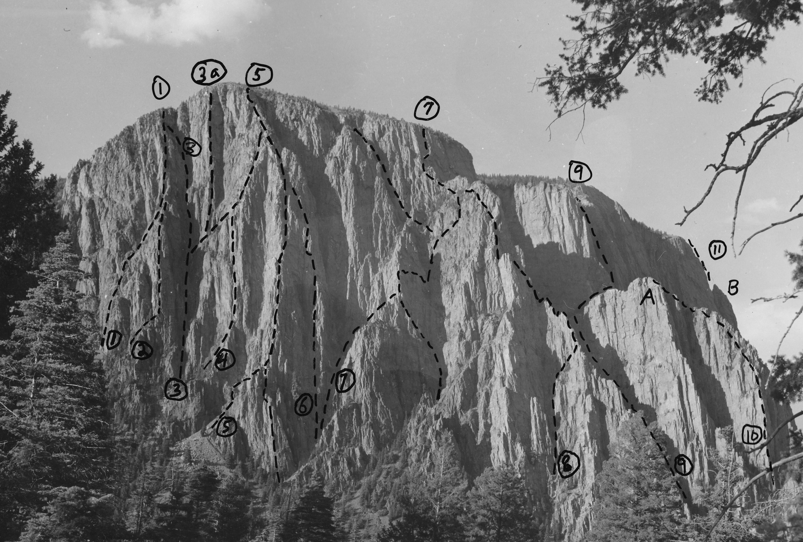
Figure 1: Main Brazos Cliffs showing some of the routes.
Descent Gully is at left of photo and Box Canyon at right.
1. "White Gully", D. and A. Liska, G. Bell, and M. Williams, 1967 (5.5).
2. "Cat Burgler", D. Liska and L. Campbell, 1971 (5.7).
3. "Great Couloir", G. Bell and D. Monk, 1952 (5.6).
3a. "Great Couloir Direct", G. Bell and D. Coward, 1956 (5.6) -
with subsequent variations by D. Liska et al.
4. F. de Saussure and Baily, 1956 (5.6).
5. "Easy Ridge", G. Bell, D. Monk, V. Lotz, and K. Brueckner, 1952 (5.6).
6. "East of Easy", G. Bell, W. Hendrey, C. Keller and R. Harder, 1970 (5.6).
7. "Going to Jerusalem", G. Bell, R. Mulford, and R. Thorn, 1957 (5.6).
8. "Pinnacle Ridge", G. Bell and F. de Saussure, 1958 (5.6).
9. "Cleft", G. Bell and F. de Saussure, 1958 (5.6).
10. "Box Tower", G. Bell and M. Haine, 1959 (5.5).
11. "Gothic Arches Buttress", D. Liska, G. Bell,
L. Dauelsberg, and M. Williams. 1969 (5.7).
A: Box Tower.
B: Gothic Tower.
|
|
Nowadays, when a climber stumbles
onto a particularly fine but unknown area,
he is tempted to talk little about it except
to a few chosen friends.
Better at least to get some of the choicest routes
before mentioning it in climbing journals
and before encouraging the hordes of other
climbers to our cliffs.
So, for the last twenty years,
we in Los Alamos have been enjoying
our favorite Brazos Cliffs in Northern New Mexico,
not exactly secretly,
since who can keep two thousand foot
cliffs secret when they are plainly visible
from a U.S. highway eight miles away,
but at least quietly.
However, age dulls the competitive appetite
and moreover the word seems to be getting around.
It therefore appeared that this might be an appropriate
time to reveal some of the facts about our Brazos playground.
For those who wish to read no farther the lesson is this:
though the cliffs look nice enough from a distance they
have many bad characteristics and consequently should be
avoided by the inexperienced.
For one thing, the rock is a particularly hard
quartzite which will defeat all attempts to drill bolt holes;
while cracks abound, they will frequently scratch or refuse
to relinquish pitons; though good holds are common,
a few areas are water polished and the rock is exceedingly
slick when wet.
In addition the cliffs are on private land and some
of the landowners are ill disposed toward any trespassers at all,
worst of ail those that are dirty, bearded, and jangling,
and considered thereby to offend the nose, the eye, and the ear.
Finally, while some of the routes are relatively easy to reach,
others can be gained, if at all, only at low water,
by wading up the treacherous rapids and icy pools of the Brazos River.
The more accessible Brazos Cliffs are the face of a 3000'
fault scarp of preCambrian quartzite which separates the
agricultural valleys at around 7500' near
Tierra Amarilla from the high meadows and forests
of the southern end of the San Juan Mountains.
The Brazos River, with its headwaters in these alpine meadows,
has eroded a deep canyon through the quartzite,
bisecting the fault scarp, and offering some of the
steepest cliffs in the area.
Truly though, the river at high water is unwadable
and these cliffs are often inaccessible.
Views of the canyon from the rim are superb;
from a level forest floor one can gaze into a
half-mile-deep gorge.
Each pine cone dislodged from the rim can be a
hazard to fishermen below.
The cliffs are approached from U.S. highway 84,
about nine miles south of Chama, New Mexico,
and one mile north of the Brazos River crossing,
by turning east onto NM 512 and driving seven
and a half miles to Brazos Lodge which is currently
the office for a land development company.
All cliffs on the north side of the river are on
the Lodge property and permission to continue should
be sought from the genial manager, Mr. Robert Hobson.
Since the roads are still incomplete, climbers are requested
to leave their cars at the Lodge and to proceed to the cliffs on foot.
The Lodge bar and restaurant is a pleasant place to
recuperate after a strenuous day on the rock.
The main cliffs, shown in figure 1 and some
times known as El Ventisquero Amarillo
can be reached in about an hour from the lodge.
The first technical climbs on the Brazos
Cliffs were made in 1952 when Don Monk and
I climbed the Easy Ridge and the Great Couloir,
which with some additions and variations are still
two of the longest (up to 17 pitches)
and finest climbs in the area.
More than 90% of the climbing has been done by
members of the Los Alamos Mountaineers (LAM).
From the Brazos Lodge, the main cliffs are seen as in photo 2.
Further left and more directly above the Lodge are less
frequently climbed and smaller cliffs,
variously broken or overhanging and thus of a reddish hue,
the unweathered color of the rock.
These smaller cliffs boast a handsome waterfall
for a few weeks during the spring runoff.
Between the main and the smaller cliffs a broad tree
and scree filled gully serves as the descent route of choice,
or alternatively as a nontechnical route to the top of the cliffs
and to the rim of the Box Canyon.
A rough trail has been worn in this gully,
adjacent to the main cliffs.
|
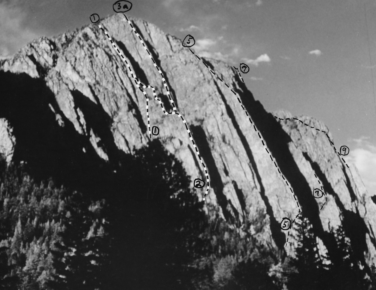
Figure 2: The main cliffs as seen from the end of the road at
Brazos Lodge.
Route numbers correspond to those shown in Figure 1.
|
|
As the main cliffs are approached through a thick forest
it is difficult to identify the various routes;
dim morning light on the southwest-facing rock
compounds the problems.
It may be helpful to note that the most prominent ridge,
"Easy Ridge," terminates at its base in a 500 foot step.
It is customary to start "Easy Ridge" above the step,
though five nice pitches may be added by starting at the lowest
point of the step.
The easiest approach is to scramble up the gully left
(west) of the step until nearly even with the top of the step.
A broad ledge can be followed to the top of the step;
then by crawling through a hole in the ridge,
ascending a 50' gully, and traversing 100' left,
the start of the technical climbing is reached.
The first pitch leads to the crest of the ridge,
the second is directly up the ridge,
the third and fourth slightly west of the crest.
At about the seventh and crux pitch
(about 5.6, with this grading and others on the photos
being perhaps a little high by present standards),
the route moves to the right edge of the ridge to a
delightfully exposed belay perch, the pedestal,
and thereafter follows a shallow gully system
just right of the ridge for 400 feet.
This brings one to the top of technical climbing,
though there are several hundred feet of
exposed scrambling at the top of the ridge.

|
|
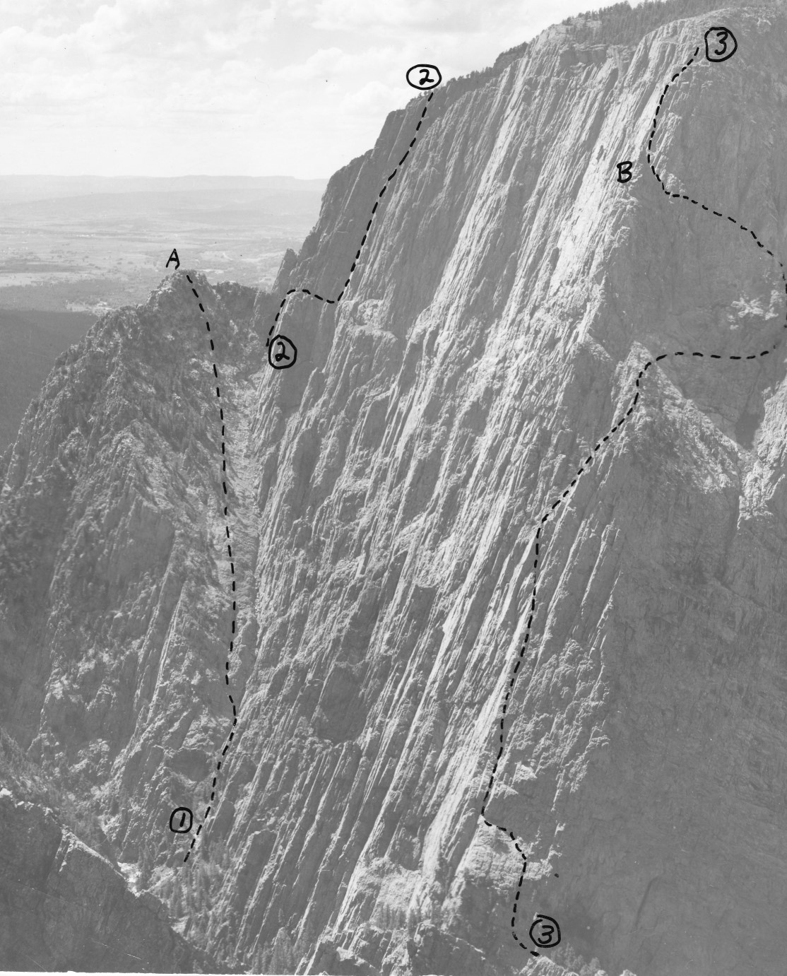
Figure 3: Southwest face of the "Wedge".
Box Canyon is to the left of these cliffs.
1 "West Ridge of the Wedge", W. Hendry and C. Keller, 1970 (5.8).
2 "Wicked Ridge of the Wedge", W. Hendry and M. Hart, 1969 (5.6).
2a D. Michael and L. Dauelsberg, 1971.
3 "Roofy Ridge of the Wedge", W. Hendry, L. Dauelsberg,
M. Hart, C. Keller, and M. Williams, 1969 (5.7).
4 "Rickety Ridge of the Wedge", LAM party 1968 (5.4).
|
|
The "Great Couloir" offers many attractive variations
to a small party-though as with most couloirs
there could be substantial rockfall hazard for a large party.
The base of the couloir can be identified as a water polished
inside corner; the first pitch avoids this to the right,
either passing a chock stone or less strenuously, on small holds
farther right.
An overhang is next passed on the left and after some scrambling,
the next overhanging section can be passed on either side,
most pleasantly by the 200' face to its left from which the
couloir is regained by an easy hand traverse.
Continuing for 200 feet on the broken left wall of the gully
one reaches a bowl from which various routes diverge.
The original route continues up the gully for four pitches
before easier rock is gained.
The first pitch ascends on small holds toward the right,
whence the gully proper is regained by a delicate move.
On the third pitch, leave the gully via a small overhang
on the left wall (5.6) where a piton may
be useful as a handhold.
The alternative routes are gained by scrambling right from
the bowl on a large ledge with two trees
(difficult move above the last tree).
One can thus reach the escape route
(continue up and to the right to reach ridge)
or the delightful direct finish
(eleven pitches more or less straight up a rib or with
occasional deviations into the gully to its right).
Liska's Finish, straight up the rib for the last 400 feet,
is particularly recommended as a sustained and exposed climax.
On continuing east, along the fault scarp,
from the main cliffs, the Brazos Box Canyon is first
encountered and then "The Encinado Wedge," a thin triangular
height of land lying between the fault and the Brazos River.
The cliffs on the south side of Encinado Wedge (figure 3)
are about 1000' high, steeper than the main cliffs,
and they have yielded some fine climbs to Bill Hendry
and others in the last few years.
These climbs cannot be easily reached from the Brazos Lodge
because the intervening land has been posted by the exclusive
Corkin resort, which caters primarily to fishermen.
An alternative approach leaves the village of Encinado
and follows dirt roads south of the Brazos River.
The last few miles require four-wheel drive and all of
the land is private but has not been posted in recent years.
By this means it is possible, at least in dry weather,
to get within an hour's hike of the fine routes shown in figure 3.
A still easier approach can be used to reach the top of the wedge
and superb views of the Box Canyon as shown in figure 4.
A new road is currently being developed across the high
plateau from Tierra Amarilla to Tres Piedras;
it is now designated NM 553 east from Tierra Amarilla
and NM 111 west from Tres Piedras and will eventually
be a part of U.S. 64.
From this road, around twenty miles east of Tierra Amarillo,
there are views of the fault scarp and it is an easy walk
of about three miles, across private land,
to the brink of the wedge.
|
|
Figure 4: Part of the Brazos Box Canyon as seen from the Wedge.
1. "the Ramp", class 4.
2. "Cleft", 3 "Gothic Arches Buttress", as in Figure 1.
A: Box Tower. B: Gothic Tower.
|
|
Finally there are several miles of cliffs along the
Brazos Box Canyon. The first problem in approaching
is to get around the posted Corkin land which extends
to the mouth of the Box, and the second problem is the
river itself which pretty well fills the canyon.
Nevertheless, several routes have been done on
the wall of the canyon, which are up to 2200 feet high.
The Gothic Arches Buttress route is shown in figure 4
and was described in the American Alpine Journal [399 (1969)];
on a second ascent last year the aid pitches were
bypassed and the Gothic Tower was climbed without a bivouac.
The best climbing is found on the north side of the River
where the strata lead to clean walls and ledges favoring
the climber.
The lands near the Brazos Cliffs have a turbulent past,
a confused present, and an uncertain future.
In the past, disputes involving the grants of Spanish
kings and conflicting water rights have often issued in violence.
At present, many people are attracted to the area by the
beauty of its streams and forests or the challenge of
its noble cliffs.
But they come with various uses in mind.
Most conspicuous and friendly are the land developers,
who dream of aerial tramways to revolving restaurants
atop the cliffs.
Others are hostile to their inroads, like Phil Corkin who
has spent his lifetime building a resort with minimal
impact on the wilderness and who now depends on it
with calculated fierceness.
Finally, there are we mountaineers who clearly perceive
that the splendid area should be preserved for all
posterity with what wilderness is left and who would
like to see the land acquired for that purpose.
The future is in doubt.
 Trip Report Index ...